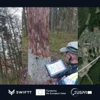
The solution will increase forest management productivity and cost-effectiveness, and enable forest managers, authorities, and policymakers to deal with forest threats proactively (IN BRIEF) Insect outbreaks, wildfires, and windthrow pose significant threats to European forests, exacerbated by climate change-induced extreme … Read the full press release →
Posted in Agriculture, Artificial Intelligence (AI), Aviation & Aerospace, Environment, European Union, France, Management, News, Science, Technology
Tagged AI, app, Ariane Kaploun, artificial-intelligence, AXA Climate, Bark Beetle, biodiversity, biomass loss, Chiara Solimini, climate change, combat climate change, copernicus, Copernicus satellites, Da Vinci Labs, droughts, earth observation data, Earth observation programme, EGNSS, EU, EU Forest Strategy, EU forests, Europe, European Commission, European forests, European Green Deal, European Union, EUSPA, Extreme weather events, forest, forest data, forest health threats, forest management, forest management tool, forest managers, forest protection, Forest restoration, forest threats, foresters, forestry, GALILEO, global navigation satellite systems, GNSS, Groupe Coopération Forestière, heatwaves, Horizon Europe, Insect outbreaks, insects, Leibniz University Hannover, Machine Learning, mapping, pathogens, Quentin d'Huart, remote sensing tools, Rigas Mezi, satellite, satellite data, satellite imagery, Sentinel, Space Research Institute of Ukraine, storms, SWIFTT, SWIFTT consortium, SWIFTT project, Timbtrack, trees, University of Bari Aldo Moro, wildfires, Wildsense, windthrow