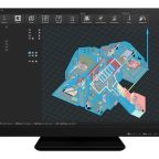
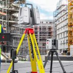
(PRESS RELEASE) HEERBRUGG, Switzerland, 15-Dec-2020 — /EuropaWire/ — Leica Geosystems, part of Hexagon, announces Leica Cyclone ENTERPRISE. The new, user-managed, enterprise-level platform provides a central tool for managing, collaborating and accessing reality capture projects to view, share and analyse rich … Read the full press release →
Posted in Construction, Industrial, News, Switzerland, Technology
Tagged 3D, autonomous, autonomous solutions, CAD, collaboration, construction, Faheem Khan, geospatial, Hexagon, infrastructure, JetStream Enterprise, Joseph Romano, LANGAN Engineering, Leica CloudWorx, Leica Cyclone ENTERPRISE, Leica Geosystems, Leica TruView LIVE, mapping, mining, project management platform, reality capture, sensor, software, surveying